
WHAT IF…? FICTIONAL MAPS
What if France became a ‘hydrocracy’?
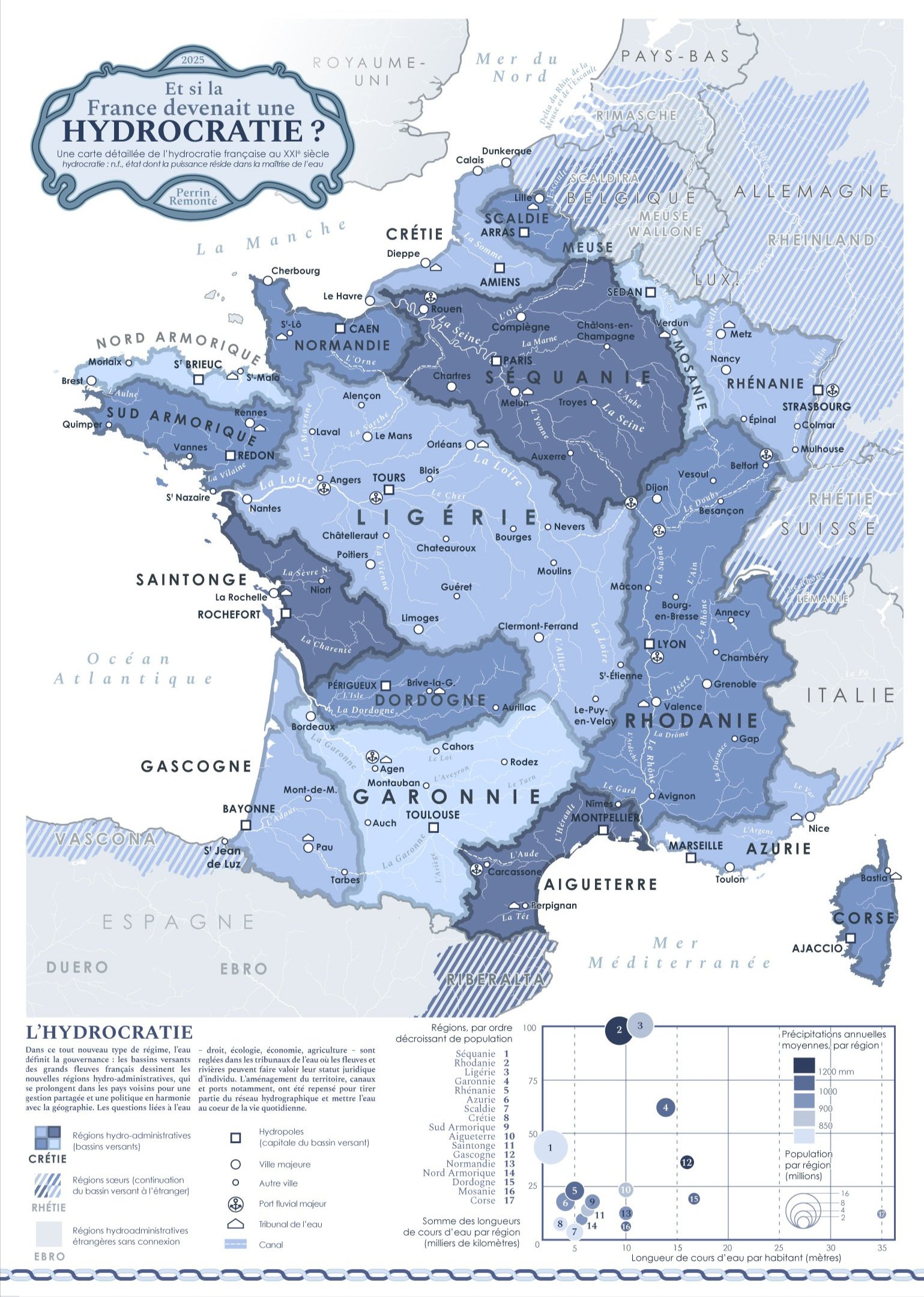
In 2025, we have democracies, oligarchies, autocracies, theocracies and recently idiocracies, so why not create a new term for this new type of water-based governance?
I'm taking some liberties here: the word is a neologism coined for my map, but we do have "Thalassocracy" in the French / English language (a state whose power is based mainly on domination of the sea), so why not extend the idea to rivers, lakes and streams? That's what this map shows!
The motto of this new country? Perhaps "Regenerate, renaturalise, let it flow". In this country divided into hydro-administrative regions (based on catchment areas), water is at the heart of planning and leads the way for our thinking, actions, how we approach geography and how we get around. It is a profoundly decentralised state since issues are now thought out and reflected upon within these hydrological territories, from upstream to downstream, from the sky to the Earth and vice versa, and no longer from a national capital.
This governance strives to preserve water as a natural, economic and cultural common good, going so far as to grant waters - lakes, rivers, wetlands and streams - a legal personality to defend and maintain them, in line with the vision defended by Charlène Descollonges (hydrologist) and Marine Calmet (environmental lawyer), for example, whose work I admire.
This decentralisation does not stop at the country's borders (which are partly catchment basin boundaries): the Rhine continues its course into Germany, the Meuse into Belgium, and this requires cooperation between neighbouring hydro regions! So the Swiss Rheinland, the French Rhineland and the German Rheinland are perhaps as closely linked as other regions in their respective countries.
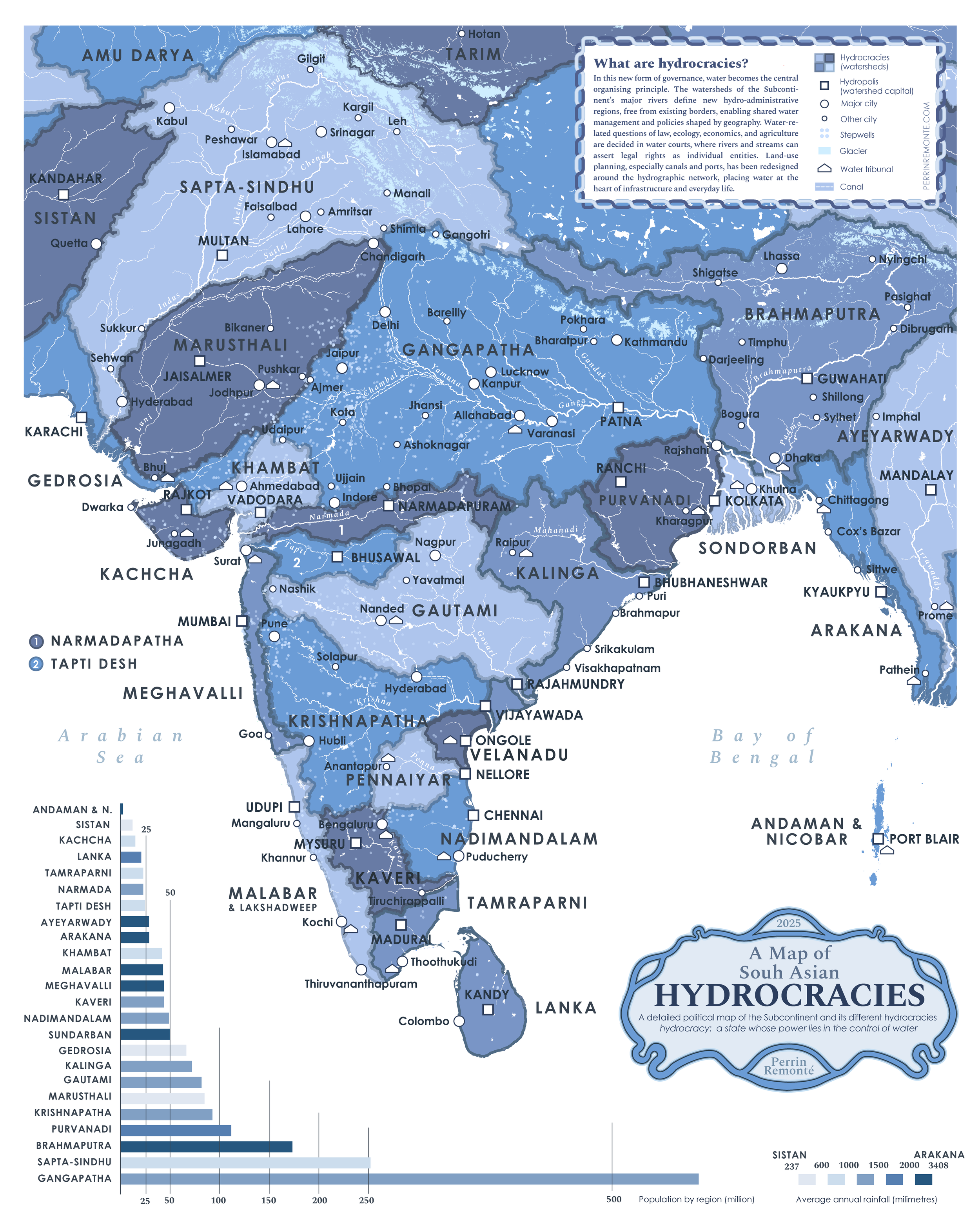
What about South Asia?
WHAT IF FORESTS
TURNED INTO MOUNTAINS?
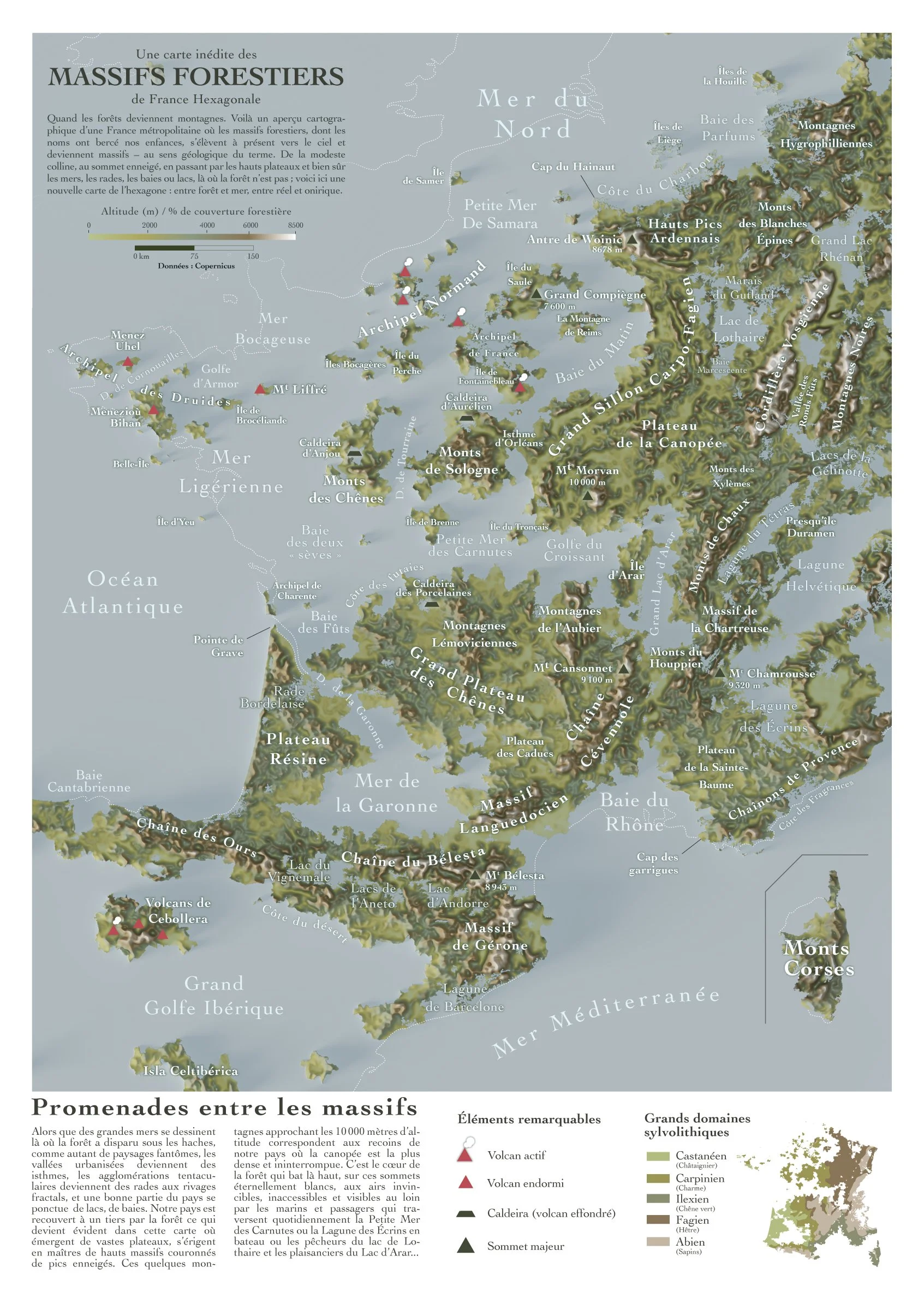
When forests become mountains! The pun works only in french: forest can translate to ‘massif forestier’ which can be understood with a bit of imagination as a massif, a mountain range. So here is a cartographic overview of metropolitan France, where the forest ranges whose names have been part of our childhoods now rise up towards the sky and become mountain ranges—in the geological sense of the term. From modest hills to snow-capped peaks, high plateaus and, of course, seas, harbors, bays and lakes, where there are no forests, here is a new map of France: between forest and sea, between reality and fantasy.
The data comes from Copernicus, the European data service. In this case, the data I used represents forest cover density. At 0% we have 0 meters (the sea) and at 100% we have a 10,000-meter mountain.
Unsurprisingly, forests and mountains largely overlap in mainland France, but not only there. Indeed, some areas hold surprises with ancient and very dense forests: the forests of Compiègne, Tronçais, Sainte Baume, Chartreuse, and Landes.
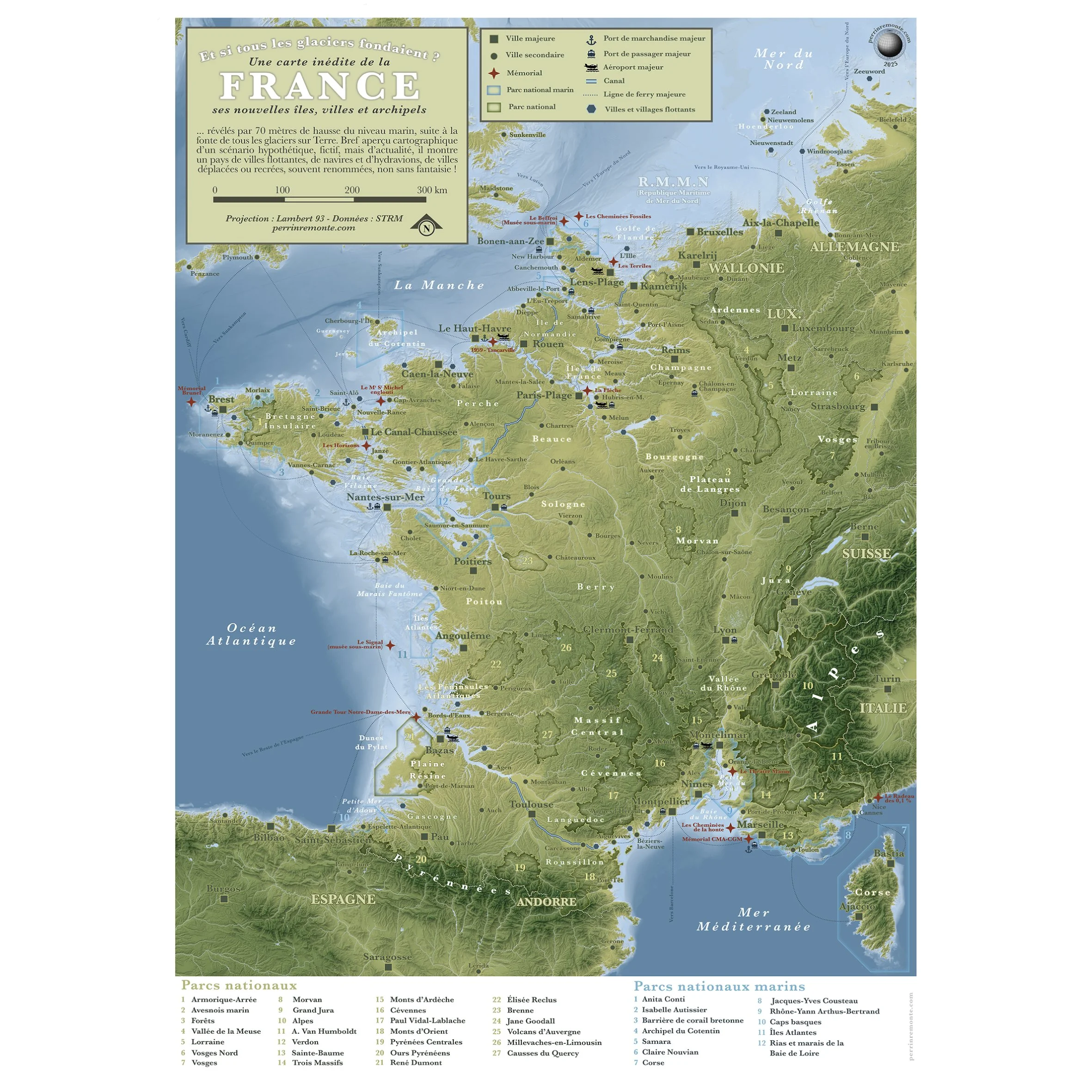
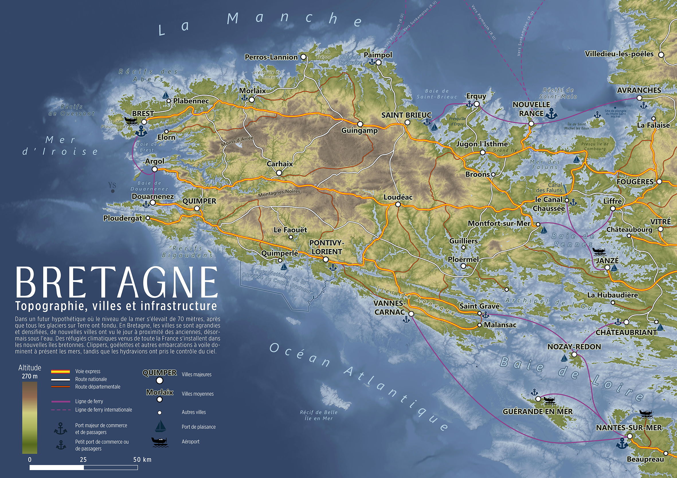
What if all the
glaciers melted?
Mainland french regions
Discover a visual illustration of this distant and hypothetical yet topical scenario in a series of 10 maps – dive headfirst into 10 maps showing mainland France if all the glaciers melted.
70 meters of sea level rise and a few population shifts later, the maps are here!

imagined my hometown surrounded by sea ice every winter. here’s what it could look like

19 janvier 2025 à Brest, la Rade est prise dans la glace, comme tous les hivers.
Ce matin je vais plonger dans la rade de Brest mais hier, alors que nous parlions avec mes coequipiers de cette plongée, j'ai eu le malheur d'entendre quelqu'un parler de la rade de Brest glacée, de la banquise dans la rade (pour plaisanter, c'est vrai que l'eau est froide en cette saison !) mais c'était trop tard : l'idée était trop tentante pour ne pas en faire une carte...
Alors voilà, dans une réalité climatique parallèle (qui m'irait très bien), la température de ce 19 janvier à Brest avoisinerait les -23°C et l'eau de la rade serait en grande partie gelée, formant une belle banquise au blanc pur et vaste, parcouru chaque jour par le service de transport en commun de bus-motoneiges et de navires à la coques renforcée, entre les différentes stations du réseau.
Stations fixes : ce sont celles dont les fondations reposent sur terre. Stations flottantes : elles dérivent et change légèrement d'emplacement selon les saisons, les courants et les glaces. Elles permettent de passer du bus ua bateau pour voyager sans limite. Ainsi, plus besoin d'une voiture pour partir de Brest, aller manger à Daoulas puis rendre visite à un ami à Lanvéoc ! Tout se ferait sur la glace. Attention aux nouveaux. prédateurs sur la glace toutefois...
Comme les eaux salées gèlent à plus basse température que l'eau douce et qu'on trouve un plus fort courant au centre de la rade jusqu'au Goulet, il est vraisemblable que la banquise soin moins présente ou fracturée à l'Ouest de la zone, sans compter sur l'Abeille Boréale (que pourrait photographier Ewan Lebourdais) navire brise glace, qui chaque jour aurait pour mission de créer un chemin entre l'Arsenal de Brest et l'Île Longue, deux sites cruciaux pour l'activité militaire à Brest et en France.
Sur ce, je vous laisse imaginer votre vie à Brest ou ailleurs en France dans un climat pareil !
What if population became mountains?
Cities would be mountains, deserted countryside would be lakes or even seas…
Here’s my attempt at showing this alternate geography!

What if rivers turned into tree?

See the entire series below, with 24 great rivers from all continents!
A map of the mediterranean, but inverted
